Aggregating points: JSON on SQL and loops on infowindows

by Jorge Sanz on

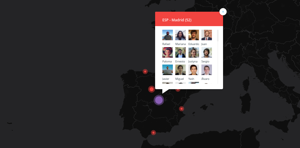
NOTE: I’ll use CARTO but you can apply all this to any webmapping technology backed by a modern database. Get all the data So we start with the typical use case where we have a one to many relationship like this: select e.cartodb_id, e.displayname, e.division, e.photourl, l.cartodb_id as locaction_id, l.location, l.the_geom_webmercator from locations l inner join employees e on e.location = l.location order by location Easy peasy, we have a map with many stacked points.

Read More…

How a daily digest of geospatial links is distributed

by Jorge Sanz on

TL;DR If you are interested on getting a daily digest of geospatial links subscribe to this mailing list or this atom feed. Take «daily» with a grain of salt. Over the last six years Raf Roset, one of my favourite geonerds out there, has been sending all the cool stuff he founds about our geospatial world to Barcelona mailing list at OSGeo mailman server. He started circa 2011 sending one link per mail, but in 2013-04-03 he started to make a daily digest.

Read More…

III Edición Geocamp ES

by Jorge Sanz on

A través de Geoinquietos Sevilla El próximo 20 de junio se celebrará en Sevilla la tercera edición de la versión española de la Geocamp este año organizada por Geoinquietos Sevilla. ¿Qué es una Geocamp? - Una desconferencia sobre temática GEO y software libre. - Evento basado en el concepto de Barcamp y que se viene celebrando desde hace tiempo en Portugal. El mundo de las tecnologías de la información geográfica (TIG) y el software libre está teniendo cada vez más peso en el mundo en que vivimos, tanto desde el punto de vista personal como profesional.

Read More…

Dear OSM, just chill out.

by Iván Sánchez on

This is kinda a reply to Gary Gale’s “Dear OSM, it’s time to get your finger out”. The more I read that, the less sense it makes to me. Update 2015-04-30: Read also Richard Fairhurst’s Realpolitik and the OpenStreetMap License and Simon Poole’s Is OSM business unfriendly? I think of myself as a Linux nerd. I consider myself a hacker. And I’ve spoken so many times about open/libre licensing in conferences the issue became boring.

Read More…

Mapping Party en Poio, Pontevedra

by Micho García on

El sábado 11 de abril en el Centro Xaime Illa de Raxó (Poio) llega la fiesta de las fiestas, la Mapping Party Poio’15 con el objetivo de pasarlo bien mientras aumentamos los datos geográficos de la costa de Poio con una licencia libre. Este taller está organizado por la asociación de software libre Xeopesca y cuenta con la colaboración del Concello de Poio y las asociaciones SCD Raxó y ACDeM Armadiña.

Read More…

EMT Madrid, or Open Data antipatterns

by Iván Sánchez on

Today, february 21st 2015, is the Open Data Day. And given that I’m far asay from my favourite Open Data nerds down at the Medialab Prado, I decided to work on giving the old ¿Cuánto Tarda Mi Autobús? website a facelift. The story behind ¿Cuánto tarda mi autobús? is rather simple. A couple of years ago I got my first smartphone, and one of the things I wanted to do is check for the bus times in Madrid.

Read More…

About Antipodes Map

by Jorge Sanz on

We’ve been pretty quiet over the last year but that doesn’t mean we’ve been unoccupied. Last summer we (Pedro and me) participated with some friends on a hackathon with a project to give to teachers from our region a tool to help them to relocate, precalculating travelling times with OSRM and some open datasets, one of them a database of schools that our government published as a spreadsheet. That gave us the chance to work and improve our knowledge on the CartoDB Platform, we used their JavaScript API to place a Leaflet map with a parametrized map where the SQL that defined the layer changed depending on user selections.

Read More…

The Null Island Algorithm

by Iván Sánchez on

We geomaticians like to gather around a mythical place called Null Island. This island has everything: airports, train stations, hotels, postcodes, all kinds of shops, a huge lot of geocoded addresses, and whatever geographical feature ends up with null coordinates due to whatever buggy geoprocessing pipeline and ends up in the (0,0) coordinates. But earlier this year, some geonerds such as @mizmay and @schuyler realized that there is no one Null Island, but one Null Island per datum / coordinate system (depending on who you ask).

Read More…

Mapping for the busy cartographer: today moving dots

by Jorge Sanz on

This article describes how to make a quick map using some nice services we have at our hands. Nowadays almost everyone can create a maps using services like CartoDB, Mapbox, uMap or even Google My Maps. In this case I’ll show how I used the incredible flexibility of CartoDB to combine some Postgres/PostGIS SQL with CartoCSS to animate some dots on top of OSM cartography rendered by Mapbox. This combination is really unique and convenient, other services only allow you to upload or draw some features and decide some static styling for them.

Read More…