The Null Island Algorithm
by Iván Sánchez on
This blogpost was migrated from the previous content management system that hosted this blog. If you want to check for old comments or to find anything looking weird please follow this link to check the Internet Wayback Machine.
We geomaticians like to gather around a mythical place called Null Island. This island has everything: airports, train stations, hotels, postcodes, all kinds of shops, a huge lot of geocoded addresses, and whatever geographical feature ends up with null coordinates due to whatever buggy geoprocessing pipeline and ends up in the (0,0) coordinates.
But earlier this year, some geonerds such as @mizmay and @schuyler realized that there is no one Null Island, but one Null Island per datum / coordinate system (depending on who you ask). And @smathermather had the spare time to find out how the “Null Archipielago” looks like:

Null archipielago image by @smathermather, containing Map tiles by Stamen Design, under CC BY 3.0. Data by OpenStreetMap, under CC BY SA
Fast forward a few months. I received an e-mail from one of my university peers, asking for help with a puzzle:
A friend of mine received a puzzle with some coordinates. He has to find a place on earth represented by 861126.41, 941711.64.
It’s supposed to be a populated place. Any ideas?
Well, off the top of my head, those looked slightly like UTM coordinates - two digits after the decimal point, suggesting centimeter precision… but the easting is way off the valid range for UTM coordinates.
And I realized this is the Null Archipielago problem, all over again; but instead of plotting (0,0) on a map, let’s plot all points having (861126.41, 941711.64) coordinates in any reference system.
Cue PostGIS. We can create a point in every CRS like so:
 select srid,
        ST_GeomFromText(
          'POINT(861126.41 941711.64)',
          srid
        ) as geom
   from spatial_ref_sys;
Note the complete absence of PL/SQL in there.
But it will be much easier to work with the data if all the points are in our beloved EPSG:4326 latitude-longitude coordinate system. And while we’re at it, let’s materialize that data into a table:
 select srid,
        ST_Transform(
          ST_GeomFromText(
            'POINT(861126.41 941711.64)',
            srid
          ),
          4326
        ) as geom
   from spatial_ref_sys;
But there is a problem with this - the PostGIS query will crash due to some CRSs having an empty Proj4 string. This took me a while to trace and fix:
 select srid,
        ST_Transform(
          ST_GeomFromText(
            'POINT(861126.41 941711.64)',
            srid
          ),
          4326
        ) as geom
   from spatial_ref_sys
  where proj4text!='';
And now we can take this data out into a file… but once again, there’s a catch: some of the coordinates are out of bounds and represented by (∞, ∞) coordinate pair. Even though file formats can handle ∞/-∞ values (good thing we know how IEEE floating point format works, right folks?), some mapping software can not accommodate for these values. And I’m looking at you, CartoDB upload page.
In this particular case, there are only points for (∞, ∞) so the data can be cleaned up in just one pass:
delete from archipielago where ST_X(geom)>180;Then just add a tiny bit of CartoDB magic, and publish a map:
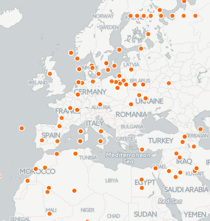
CartoDB archipielago map
https://ivansanchez.cartodb.com/viz/1ac4a786-805a-11e4-bc48-0e853d047bba/public_map
I still don’t know if the original puzzle has anything to do with any obscure used-in-the-real-world CRS, but at least it’s worth a try.
Updated: 2022-03-02, Version: 11d47a4.